
Fail:20220113 Hunga Volcano.gif

Necen ezikacundan suruz': 800 × 450 piksel'ad. Toine laskendad: 320 × 180 piksel'ad | 640 × 360 piksel'ad | 960 × 540 piksel'ad.
Originaline fail (960 × 540 piksel'ad, failan suruz': 1,6 mb, MIME-tip: image/gif, toštase, 8 kadrad, 8,0s)
Lühüd kirjutuz
| Kirjutuz |
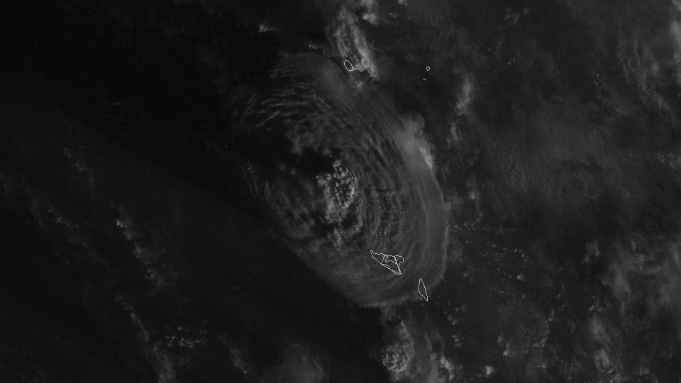
English: On Jan. 13, 2022, NOAA’s GOES West satellite captured another explosive eruption of the Hunga Tonga-Hunga Ha'apai volcano, located in the South Pacific Kingdom of Tonga. According to local officials, the eruption had a radius of 260 km (161.5 miles), and sent ash, steam, and gas 20 kilometers (12.4 miles) into the air. It was also about seven times more powerful than the previous eruption on Dec. 20, 2021. Additionally, a tidal gauge in Nuku'alofa, the capital of Tonga, measured a 30 cm (one foot) tsunami wave that resulted from the blast. In this visible imagery from the satellite, we can see the extent of the ash plume as well as multiple rippling gravity waves emanating outward. This type of imagery from the “red” visible band has the finest spatial resolution of all the bands on the satellite’s Advanced Baseline Imager, making it ideal to identify small-scale features.
Українська: 13 січня 2022 року супутник NOAA GOES West зафіксував чергове вибухове виверження вулкана Хунга-Тонга-Хунга-Хаапай, розташованого в південно-тихоокеанському Королівстві Тонга. За словами місцевих чиновників, виверження мало радіус 260 км і підняло попіл, пару та газ на 20 кілометрів у повітря. Воно також було приблизно в сім разів потужнішим, ніж попереднє виверження 20 грудня 2021 року. Крім того, припливний датчик у Нукуалофа, столиці Тонга, виміряв хвилю цунамі довжиною 30 см, що виникла в результаті вибуху. На цьому видимому зображенні із супутника ми бачимо масштаби шлейфу попелу, а також численні гравітаційні хвилі, що виходять назовні. Цей тип зображень із «червоної» видимої смуги має найкращу просторову роздільну здатність серед усіх діапазонів у «Advanced Baseline Imager» супутника, що робить його ідеальним для визначення дрібномасштабних об’єктів. |
| Päiv | Pildistamisaeg 13. Viluku 2022, 18:00 UTC (approximately) |
| Augotižtekst | https://www.nesdis.noaa.gov/news/hunga-tonga-hunga-haapai-erupts-again (image link) |
| Tegii | NOAA/NESDIS/STAR |
Hinnang
| This file was selected as the media of the day for 17 February 2022. It was captioned as follows:
English: On 13 Jan 2022, NOAA's GOES West satellite captured another explosive eruption of the Hunga Tonga-Hunga Ha'apai volcano, located in the South Pacific Kingdom of Tonga.
In the above visible imagery from the satellite, we can see the extent of the ash plume as well as multiple rippling gravity waves emanating outward. This type of imagery from the "red" visible band has the finest spatial resolution of all the bands on the satellite's Advanced Baseline Imager, making it ideal to identify small-scale features. Other languages
Čeština: Dne 13. ledna 2022 zachytil satelit NOAA GOES West další explozivní erupci sopky na ostrovech Hunga Tonga – Hunga Haʻapai v jižním Pacifiku ve státě (království) Tonga. Na viditelných snímcích z družice nahoře můžeme vidět rozsah oblaku popela a také četné vlnící se gravitační vlny vycházející od výbuchu. Tento typ snímků z „červeného“ viditelného pásma má nejjemnější prostorové rozlišení ze všech použitelých vlnových pásem na družici, takže je ideální pro identifikaci menších objektů . English: On 13 Jan 2022, NOAA's GOES West satellite captured another explosive eruption of the Hunga Tonga-Hunga Ha'apai volcano, located in the South Pacific Kingdom of Tonga. In the above visible imagery from the satellite, we can see the extent of the ash plume as well as multiple rippling gravity waves emanating outward. This type of imagery from the "red" visible band has the finest spatial resolution of all the bands on the satellite's Advanced Baseline Imager, making it ideal to identify small-scale features. Эрзянь: 2022 иень якшамковонь 13 чистэ NOAA GOES West неизеть Хунга-Тонга-Хунга-Хаапай вулканонть, кона ашти Сельме Океанонь лембеёно Танго Инязмасторонть. Українська: 13 січня 2022 року супутник NOAA GOES West зафіксував чергове вибухове виверження вулкана Хунга-Тонга-Хунга-Хаапай, розташованого в південно-тихоокеанському Королівстві Тонга.
|
Licenzii
See pilt on avalikus omandis, sest pildimaterjal pärineb Ameerika Ühendriikide Riiklikust Ookeani- ja Atmosfäärivalitsusest, olles selle teenistuja tehtud ametikohustuste täitmise ajal.
|
Failan istorii
Paina päiväle/aigale, miše nägištada, mitte fail oli sil aigal.
| Päiv/Aig | Kuvaine | Suruded | Kävutai | Kirjutez | |
|---|---|---|---|---|---|
| nügüdläine | 15. Viluku 2022, kell 11:26 | | 960 × 540 (1,6 mb) | RZuo | Transferred from https://www.nesdis.noaa.gov/s3dl?path=/s3/2022-01/20220113-HungaVolcanoA.gif |
Failan kävutamine
Nece lehtpol' kävutab necidä failad: