
Fail:Caribbean Sea Gulf of Mexico shaded relief bathymetry land map.png
Originaline fail (1024 × 664 piksel'ad, failan suruz': 1,1 mb, MIME-tip: image/png)
Lühüd kirjutuz
| Kirjutuz |
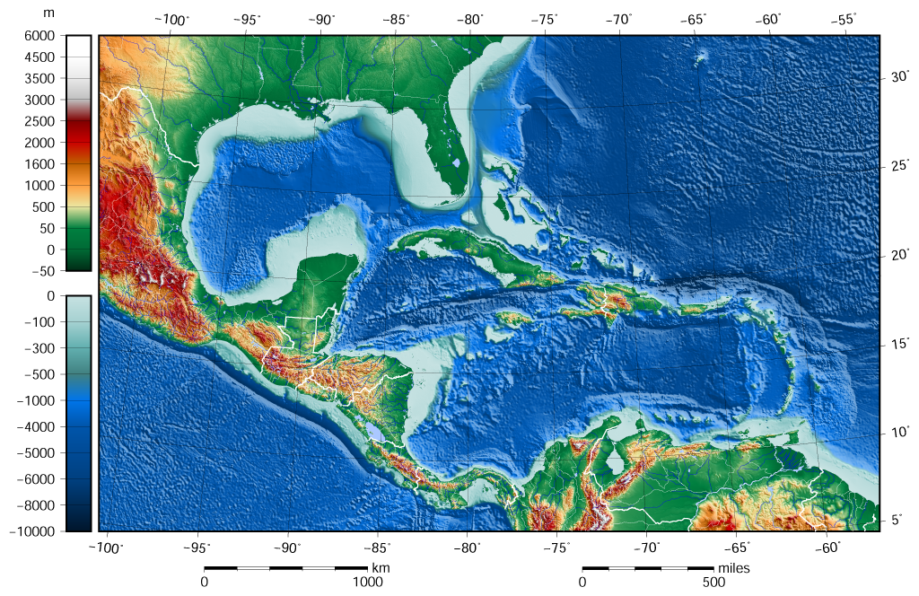
English: The shaded relief bathymetry and land map of the Caribbean Sea and Gulf of Mexico area. The map was created using the Generic Mapping Tools, GMT, version 5.1.1. |
| Päiv | |
| Augotižtekst |
Own work using: the following Public Domain datasets for the relief:
|
| Tegii | Darekk2 using the ETOPO1 and GLOBE tiles |
| Teised versioonid |
The same image but contoured at -100 m: |

Licenzii
Attribution (in addition to the author of this map):
The NGDC in it's copyright notice says:
As required by 17 U.S.C. 403, third parties producing copyrighted works consisting predominantly of the material produced by U.S. government agencies must provide notice with such work(s) identifying the U.S. Government material incorporated and stating that such material is not subject to copyright protection within the United States. (...)
(for credits see the Source section).
and GLOBE and ETOPO1
(see above and the Source section)
- Sinä oled valdal
- jagadas – kopiruida, levenzoitta da oigeta radon
- koheta – kebnenzoitta radon
- Mugoižiden sändoiden mödhe:
- tegii – Sinei pidab arvostada, antta tarkendusen licenzijale, da homaita, om-ik tehtud vajehtusid. Sinä void tehta necidä hot' miččes taht formas, no ala meleta, miše licenzijan pidäi hüväksib sindai libo sinun kävutandad.
- ühtejitte jagamine – Ku sinä vajehtad, libo parembzoitad materialad, sinei pidab painda sidä same or compatible license originaližes variantas.
Failan istorii
Paina päiväle/aigale, miše nägištada, mitte fail oli sil aigal.
| Päiv/Aig | Kuvaine | Suruded | Kävutai | Kirjutez | |
|---|---|---|---|---|---|
| nügüdläine | 8. Kezaku 2015, kell 12:58 | | 1024 × 664 (1,1 mb) | Darekk2 | added lakes ... and changed palette for land (white highest mountains) |
| 12. Semendku 2015, kell 18:23 |  | 1024 × 664 (1,09 mb) | Darekk2 | changed the illumination azimuth from 100 to 45 deg. | |
| 21. Keväz’ku 2015, kell 18:59 |  | 1024 × 664 (1,11 mb) | Darekk2 | a little wider in the east | |
| 21. Keväz’ku 2015, kell 18:07 |  | 1024 × 664 (1,11 mb) | Darekk2 | changed parallels of the projection, removed black borderline | |
| 19. Keväz’ku 2015, kell 18:05 |  | 1024 × 684 (1,15 mb) | Darekk2 | shortened elevation and depth legends | |
| 18. Keväz’ku 2015, kell 21:25 |  | 1024 × 684 (1,15 mb) | Darekk2 | User created page with UploadWizard |
Failan kävutamine
Nece lehtpol' kävutab necidä failad:
Failan leved kävutamine
Nene toižed wiki-lehtpoled kävutaba necidä failad:
- Kävutamine ar.wikipedia.org
- Kävutamine avk.wikipedia.org
- Kävutamine en.wikipedia.org
- Kävutamine gl.wikipedia.org
- Kävutamine hr.wikipedia.org
- Kävutamine sd.wikipedia.org
- Kävutamine sr.wikipedia.org