
Fail:RegionsHungary.png
Paremb versii om soubas.
RegionsHungary.png (760 × 500 piksel'ad, failan suruz': 122 kb, MIME-tip: image/png)

|
See pilt tuleks konverteerida kasutades vektorgraafikat (SVG-vorming). Vektorkujutisel on mitmeid eeliseid. Konverteerimise kohta vaata täpsemalt siit. Kui sellest pildist on vektorkujutis juba saadaval, siis pane selle malli asemele {{vector version available|uue pildi nimi.svg}}.
|
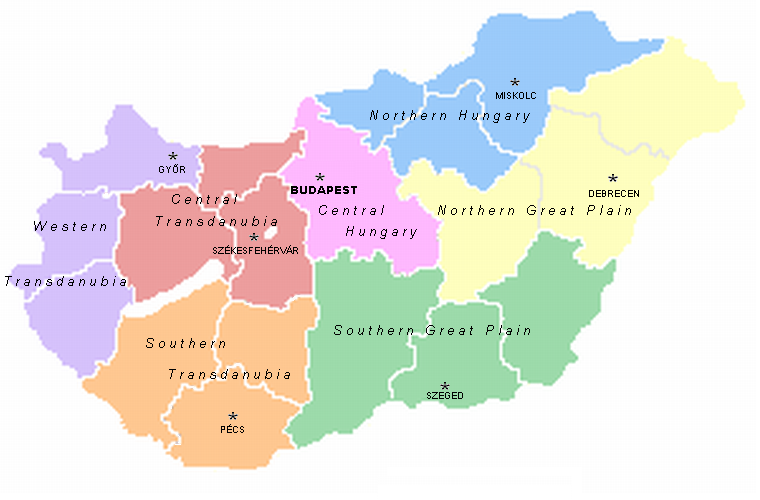
A map of the seven statistical regions of Hungary with their regional centres. It was made by User:Alensha by modifying the maps of the counties that also can be found here. If it means that the copyright is mine then I release it to public domain but if it belongs to the guy who made the pic Zalamegye.png from which it was modified, then it is GNU FDL.

|
Om anttud laskend kopiruida, levenzoitta da/libo tehta vajehtusid azjbumagas sändoiden mödhe GNU Free Documentation License, Versii 1.2 libo möhemba paindud versii Free Software Foundation; vajehtamatomita paloita, tekstoita ezikorel, da tekstoita tagakorel. Licenzijan kopii om antud eriži GNU Free Documentation License. |
| Necidä failad voib kävutada Creative Commons Attribution-Share Alike 3.0 Unported licenzijan mödhe. | ||
| ||
| See litsentsimärgis lisati sellele failile GFDL-i litsentsimisuuenduse raames. |
Failan istorii
Paina päiväle/aigale, miše nägištada, mitte fail oli sil aigal.
| Päiv/Aig | Kuvaine | Suruded | Kävutai | Kirjutez | |
|---|---|---|---|---|---|
| nügüdläine | 2. Keväz’ku 2007, kell 16:09 | | 760 × 500 (122 kb) | Tene~commonswiki | Optimised (5) |
| 21. Semendku 2005, kell 17:07 |  | 760 × 500 (164 kb) | Alensha | A map of the seven statistical regions of Hungary with their regional centres. It was made by User:Alensha by modifying the maps of the counties that also can be found here. If it means that the copyright is mine then I release it to public domain but |
Failan kävutamine
Nece lehtpol' kävutab necidä failad:
Failan leved kävutamine
Nene toižed wiki-lehtpoled kävutaba necidä failad:
- Kävutamine ast.wikipedia.org
- Kävutamine az.wikipedia.org
- Kävutamine be.wikipedia.org
- Kävutamine bs.wikipedia.org
- Kävutamine ca.wikipedia.org
- Kävutamine da.wikipedia.org
- Kävutamine de.wikipedia.org
- Kävutamine el.wikipedia.org
- Kävutamine en.wikipedia.org
- Kävutamine es.wikipedia.org
- Kävutamine fa.wikipedia.org
- Kävutamine fr.wikipedia.org
- Kävutamine gl.wikipedia.org
- Kävutamine he.wikipedia.org
- Kävutamine hr.wikipedia.org
- Kävutamine kk.wikipedia.org
- Kävutamine lt.wikipedia.org
- Kävutamine mt.wikipedia.org
- Kävutamine nl.wikipedia.org
Kaculevenzoitud kävutamine neciš failas.