
Fail:Dülmen, Merfeld, Feldweg am Mühlenbach -- 2021 -- 4278-80.jpg
Necen ezikacundan suruz': 800 × 533 piksel'ad. Toine laskendad: 320 × 213 piksel'ad | 640 × 427 piksel'ad | 1024 × 683 piksel'ad | 1280 × 853 piksel'ad | 2560 × 1707 piksel'ad | 6703 × 4469 piksel'ad.
Originaline fail (6703 × 4469 piksel'ad, failan suruz': 17,11 mb, MIME-tip: image/jpeg)
Lühüd kirjutuz
| Kirjutuz |
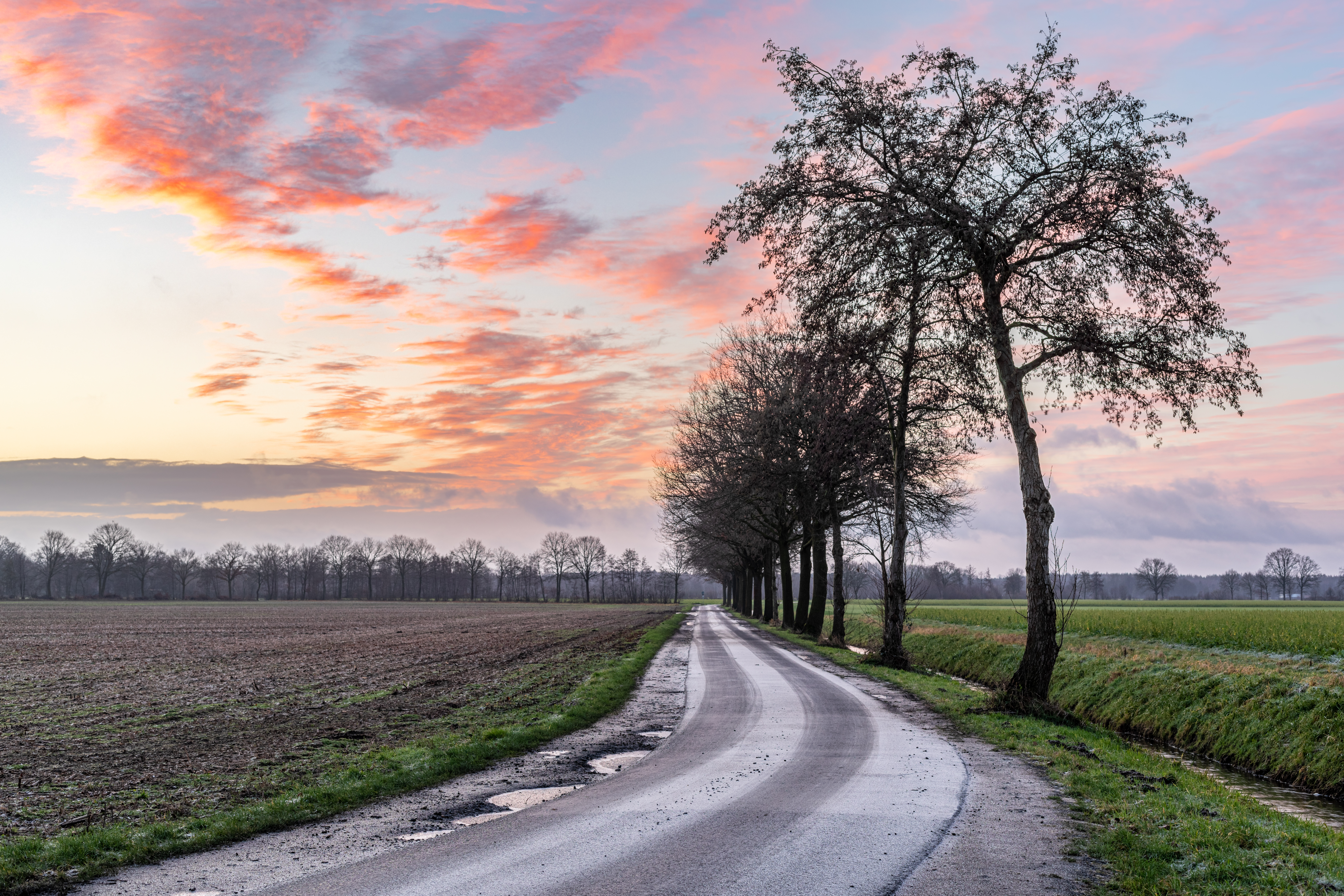
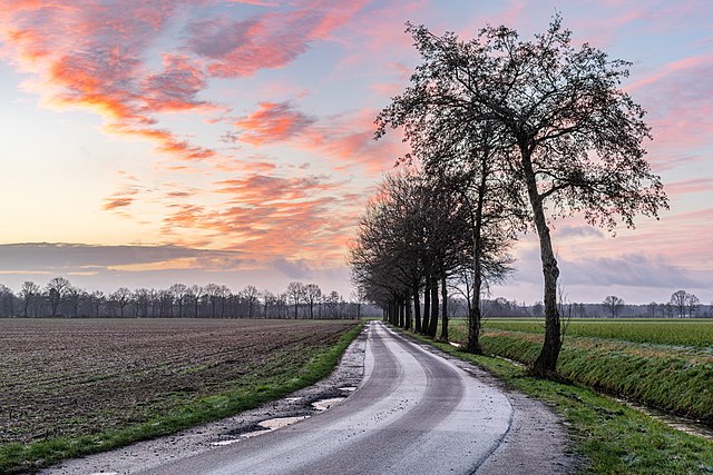
Deutsch: Wirtschaftsweg am Mühlenbach in der Bauerschaft in Merfeld, Dülmen, Nordrhein-Westfalen, Deutschland
Dansk: Gårdsvej langs Mühlenbach i Bauerschaft i Merfeld, Dülmen, Nordrhein-Westfalen, Tyskland
Ελληνικά: Αγροτικός δρόμος κατά μήκος του Mühlenbach στο Bauerschaft στο Merfeld, Dülmen, Βόρεια Ρηνανία-Βεστφαλία, Γερμανία
Español: Carretera agrícola helada y arroyo con árboles cerca de Merfeld en Dülmen, Renania del Norte-Westfalia, Alemania
Français : Chemin d’exploitation au Mühlenbach dans la Bauerschaft à Merfeld, Dülmen, Rhénanie-du-Nord-Westphalie, Allemagne
Italiano: Sentiero agricolo lungo il Mühlenbach nella Bauerschaft di Merfeld, Dülmen, Renania Settentrionale-Vestfalia, Germania
Lietuvių: Ūkio kelias palei Mühlenbach upę Bauerschaft in Merfeld, Dülmen, Šiaurės Reinas-Vestfalija, Vokietija
Nederlands: Boerderijpad langs de Mühlenbach in de Bauerschaft in Merfeld, Dülmen, Noordrijn-Westfalen, Duitsland
Polski: Droga rolnicza wzdłuż rzeki Mühlenbach w gminie Bauerschaft w Merfeld, Dülmen, Nadrenia Północna-Westfalia, Niemcy
Русский: Сельскохозяйственная дорога у ручья Мюленбах фермерского сообщества в Мерфельде, Дюльмен, Северный Рейн-Вестфалия, Германия (2021 г.)
Slovenščina: Kmečka pot ob reki Mühlenbach na območju Bauerschaft in Merfeld, Dülmen, Severno Porenje-Vestfalija, Nemčija
Türkçe: Merfeld, Dülmen, Kuzey Ren-Vestfalya, Almanya’daki Bauerschaft’ta Mühlenbach boyunca uzanan çiftlik yolu
|
||||||||||||||||||||||||||||||||
| Asukoht | |||||||||||||||||||||||||||||||||
| Kujutab | farm road – service road that serves predominantly agricultural or forestry purposes and has only local significance | ||||||||||||||||||||||||||||||||
| Technical Specifications |
|
||||||||||||||||||||||||||||||||
| Image data |
|
||||||||||||||||||||||||||||||||
| Päiv | Pildistamisaeg 13. Viluku 2021, 08:20 | ||||||||||||||||||||||||||||||||
| Augotižtekst | Ičeze rad | ||||||||||||||||||||||||||||||||
| Tegii |
|
||||||||||||||||||||||||||||||||
| Laskend (Failan toine kävutamine) |
 .svg) I. Licence
This photograph is protected by copyright law. However, it may be used for free by anyone, provided it is used in accordance with the license Creative Commons License “Attribution-ShareAlike 4.0 International” (CC BY-SA 4.0). These include, among other things, the naming of the author and the license, as well as the setting of a link to the license text or its complete imprint. The attribution should be done as follows:
Please read the text of the license carefully before using the photograph. If you do not agree with the conditions of the license or if you do not understand these conditions, please refrain from using the photo. If you have any questions regarding the license or the reuse of the image, please contact me before using it. If you do not comply with the terms of the license, you do not acquire any right to use the image. If you need another license to use, please contact the author before using.
For informations about the licence see section Licenzii or as human-readable summary or as full licence text at Creative Commons. In addition to the above, a link to the source - so this page with the descriptions and license terms - is appreciated. More information or examples of use can be found at re-use (with example file). The Attribution Generator is helpful in licensing matters.
As an alternative to the Creative Commons License CC BY-SA 4.0, the Free Art License (from version 1.3) may also be used.
II. Fairness
From printed materials and other tangible products that use that work, the user is asked to send a copy to the author as thank you. However, this is not a condition for the use of the photo, but a voluntary service. The mailing address can be requested via the contact options.
Please note that the author had quite considerable effort to draw up this file. Thus, it is only fair to comply with the conditions of free licenses listed here. In the case of violation of the license conditions, the rights granted hereunder will expire automatically.
III. Disclaimer
Please note that the license applies solely for the reuse of the photograph itself. The license doesn't grant you any right regarding the depicted object (eg, copyright or proprietary rights) or the personality rights of the person eventually shown. (See licences and non-copyright restrictions.) I do not grant any warranty that the subsequent use of the photograph is legally possible concerning the object or person shown in the photograph. You are responsible to check and respect these rights in the publication in the respective medium or country.
The author is not responsible for the accuracy of the information contained herein (description, title, etc.). Likewise, the author assumes no liability for further use. Please note the general disclaimer and please read reusing content outside Wikimedia too.
IV. Contact
|
||||||||||||||||||||||||||||||||
| Tegii (litsentsi järgi nõutav) | Dietmar Rabich / Wikimedia Commons / /
|
||||||||||||||||||||||||||||||||
| Short URL | https://w.wiki/9AwE, https://w.wiki/_ts6o (Shortlink) |
||||||||||||||||||||||||||||||||
| Keywords | Acker, Available light, Bach, Bauerschaft, Baum, Bäume und Wälder, Bild des Tages, Blau, Blue, Bodies of water, Contre-jour, Contre-jour photography, Dämmerung, Deutschland, Dülmen, Eins, Eis, Exzellentes Bild, Featured picture, Feld, Felder und Wiesen, Field, Flora, Fluss, Forest, Fotokunst, Gegenlicht, Geographie, Germany, Gewässer, Green, Grün, HDR, HDRI, HDR-Image, HDR image, High Dynamic Range Image, Kreis Coesfeld, Landscape, Landscape photography, Landschaft, Landschaftsfotografie, Landwirtschaft, Licht und Schatten, Meadow, Merfeld, Möbel, Morgen, Münsterland, Natur, Nordrhein-Westfalen, North Rhine-Westphalia, Object, Objekt, One, Orange, Pflanze, Picture of the day, Plant, Pond, Qualitätsbild, Quality image, River, Road, Schutzgebiet, Sonne, Sonnenaufgang, Stadtmöbel, Straße, Straßenmöbel, Straßen und Wege, Stream, Street, Sunrise, Teich, Tone-mapped HDR image, Transport, Tree, Tree photography, Verkehr, Wald, Wasser, Westfalen, Wetter, Wiese, Winter, Wirtschaftsweg, Wolke, 1, 2021 | ||||||||||||||||||||||||||||||||


| Kaamera asukoht | | See ja teised pildid sellest paigast lehel: OpenStreetMap |
|---|
| NOTE: For this image, at least three individual images were combined as a High Dynamic Range Image (HDRI) and tone mapping (or as an exposure fusion (pseudo HDRI)) and were thereby processed digitally. Therefore, this picture may not reflect reality exactly in every detail. |
Hinnang
|
This image was selected as picture of the day on Wikimedia Commons for 2 November 2022. It was captioned as follows: Other languages:
Čeština: Zledovatělá cesta k farmě u německé vesnice Merfeld a města Dülmen ve spolkové zemi Severní Porýní-Vestfálsko za východu slunce. Deutsch: Eisbedeckter Wirtschaftsweg bei Sonnenaufgang nahe Merfeld in Dülmen, Nordrhein-Westfalen, Deutschland Español: Camino agrícola cubierto de hielo, cerca de Merfeld, Dülmen, Renania del Norte-Westfalia, Alemania. Français : Lever de soleil hivernal près de Dülmen (Allemagne). Magyar: Jeges mezőgazdasági út napfelkeltekor Merfeld közelében (Dülmen, Észak-Rajna-Vesztfália, Németország) Português: Estrada rural coberta de gelo ao nascer do sol perto de Merfeld, Dülmen, Renânia do Norte-Vestefália, Alemanha. Українська: Покрита льодом польова дорога на світанку поблизу Мерфельда, Дюльмен, Північний Рейн-Вестфалія, Німеччина. 日本語: ドイツにあるノルトライン・ヴェストファーレン州の日の出に照らされる氷に覆われた農道 |
Licenzii
Dietmar Rabich autoriõiguse omanikuna avaldab selle teose järgmise litsentsi all:
See fail kuulub Creative Commonsi rahvusvahelise litsentsi "Autorile viitamine + jagamine samadel tingimustel 4.0" alla.
Tegii: Dietmar Rabich
- Sinä oled valdal
- jagadas – kopiruida, levenzoitta da oigeta radon
- koheta – kebnenzoitta radon
- Mugoižiden sändoiden mödhe:
- tegii – Sinei pidab arvostada, antta tarkendusen licenzijale, da homaita, om-ik tehtud vajehtusid. Sinä void tehta necidä hot' miččes taht formas, no ala meleta, miše licenzijan pidäi hüväksib sindai libo sinun kävutandad.
- ühtejitte jagamine – Ku sinä vajehtad, libo parembzoitad materialad, sinei pidab painda sidä same or compatible license originaližes variantas.
Notes
Fotods
|
You like this photograph? That pleases me very much! You would like to see more of my pictures? With pleasure.
Wikimedia Commons has a large number of my photographs available under a free license. This makes it easy for you and me. The license details are for each picture. The use is easier than you think, because in essence, this is just the attribution in the form I want. In addition, usage notes are listed for each picture. And if it does not fit, just ask. My contact information is also available with every photograph. |


Failan istorii
Paina päiväle/aigale, miše nägištada, mitte fail oli sil aigal.
| Päiv/Aig | Kuvaine | Suruded | Kävutai | Kirjutez | |
|---|---|---|---|---|---|
| nügüdläine | 13. Viluku 2021, kell 16:43 | | 6703 × 4469 (17,11 mb) | XRay | rm dust spot |
| 13. Viluku 2021, kell 15:43 |  | 6703 × 4469 (17,11 mb) | XRay | Uploaded with LrMediaWiki 0.8.0, LR 10.1.1 Mac |
Failan kävutamine
Nece lehtpol' kävutab necidä failad:
Failan leved kävutamine
Nene toižed wiki-lehtpoled kävutaba necidä failad:
- Kävutamine alt.wikipedia.org
- Kävutamine av.wikipedia.org
- Kävutamine cv.wikipedia.org
- Kävutamine de.wikipedia.org
- Kävutamine hu.wikipedia.org
- Kävutamine it.wiktionary.org
- Kävutamine kk.wikipedia.org
- Kävutamine ko.wikipedia.org
- Kävutamine lbe.wikipedia.org
- Kävutamine lez.wikipedia.org
- Kävutamine mk.wikipedia.org
- Kävutamine os.wikipedia.org
- Kävutamine pt.wikipedia.org
- Kävutamine ru.wikipedia.org
- Kävutamine sah.wikipedia.org
- Kävutamine uk.wikipedia.org
- Kävutamine uz.wikipedia.org
- Kävutamine www.wikidata.org
- Kävutamine zh.wikipedia.org